
The sky stretches far in central Washington and usually it’s dry; two good reasons to ride the Columbia Plateau Trail (CPT) from the Tri Cities to Spokane. The route goes first along the Snake River, then cuts through Devil’s Canyon and meanders through the Scablands, and lastly flies through the ponderosa pines in the Turnbull National Wildlife Refuge.
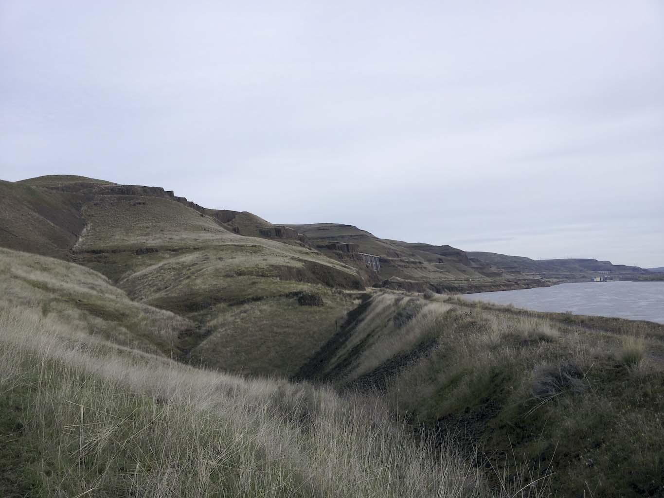
I admit that I had not heard the term Scablands before, and so I did not know that the mini-version of Monument Valley that I would be riding through had any special significance in geology. The meaning of the word Scablands apparently is not well known, but it was coined in the 1920’s by geologist G.J.H. Bretz. Wikipedia has a good entry describing the debate surrounding this large-scale geological feature in central Washington. Apparently a big, big flood happened about 16,000 years ago after a big lake drained suddenly. These geological feature are apparently similar to Mars, where large, rapid outflows occurred and then stopped.

The Scablands near Horeshoe lake between Benge and Lamont, WA.

Aerial view of the same lakes from Google.

Some canyons on Mars from Google.
The Columbia Plateau Trail was established in 1991 after the Burlington Northern Railroad abandoned the tracks and the right of way was handed to the State of Washington as it is now a state park. This 20+ feet wide railroad grade is still in fairly good shape, though the sleepers have been removed and some of those are stacked in a big piles north of Lamont, WA, on Mullen Road. The right-of-way extends about 100′ in either direction, as indicated by fence markers along the trail.
The trail surface has not been improved for most of the route, meaning coarse railroad ballast is the norm. A fatbike with 4″+ wide tires is the only way to do this IMO. Walking would be possible, but one would surely twist an ankle. A normal mountain may also work if one didn’t mind several unplanned dismounts on the rolly, rocky surface. In general, making progress looks like this:
I was holding my camera with one hand and steering with the other, so this looks a bit more shaky and wobbly than it really was. In any case it is slow going: 7 mph is a good speed, though one can certainly go faster and amazingly the amount of bumpiness does not change with speed; slow or fast, it all feels the same.
The best seasons to be riding the Columbia Plateau Trail (CPT) are spring and fall when the weather is moderate. The weather can change quickly and turn from cool and rainy to windy, to hot and stale within 24 hours. One should be prepared with a good assortment of layers.
The sounds along the trail are diverse and interesting, and can be heard over far distances. The song from birds carries all the way across the wide Snake River, as do the sounds of tractors, trains, and other motorized things. With gravel beneath the rolling tires being pretty loud, one has to stop every now and then to listen and let the expanse of the land soak in.

Along the Snake River.
Quite a variety of wildlife can be seen. Small feathered friends come in red, yellow and blue, and bigger ones include hawks, goshawk, turkeys, grouse, ducks and geez. Surprisingly, along the scablands are various wet lands and beavers can be seen running around there.

Reeds growing in a section of the CPT near Lamont.
Small towns along the way are the best places to restock on food and water. A small convenience store/deli has opened in Kahlotus (open 9-5 Monday-Friday, closed Sat., Sun.) and a bar also appears to be open daily. Washtucna also has a bar that serves good food and beverages.

Convenience store in Kahlotus

Bar in Kahlotus.
Clear-looking water is flowing under the trestle crossing the Cow Creek. With cows everywhere, careful filtration would be advised.

The Cow Creek flowing under the closed trestle.
Note that Winddust park is closed and the water pipes are empty between 2 September and 15 May. In Benge, the little store has long been closed, but an elementary school on the north side of town appears to have a outside spigot. Friendly locals may also be available to help with liquid refreshments. Don’t underestimate how much water is needed for this trip: it’s dry and hot – and riding a fatbike on ballast means a lot of sweating.

Closed store in Benge.

Church in Benge, WA.
25 miles (or 4 hours if you’re riding quickly) north of Benge is the town of Lamont where 3 spigots in the town park provide plenty of refreshment. That’s about it in terms of water along the remote sections. I suppose that there is always the Snake River, but I was concerned about agricultural run-off.
An interesting side story about water in this area is that Kahlotus is situated in a valley that used to have an ample supply of groundwater. According to a chatty local, the ground water supply is nearly gone due to irrigation. Without rivers to in this area, the town must face some dramatic changes in the next 8 years. Most maps still show a lake north-east of Kahlotus, but that is now just dry ground.

Former lake near Kahlotus.
Another interesting side note about Kahlotus and Washtucna is they got their names mixed up for a little while when the rail road was built. What happened was simply that someone from the Northern Pacific Railroad dropped off the signs at wrong towns! The Indian name Kahlotus means “hole in the ground” or “stinking water” due to the high alkaline content in the lake.
There are quite a few big trestles along the Snake River and these are closed as described by CrazyGuyOnABike. It would be a very impressive (silly?) task to ride this section of the CPT and scramble down&up to bypass the trestles. The trestles are impressive structures and luckily they can be enjoyed from a secondary track that runs below the CPT along the Snake River. This secondary track is the obvious route to take along the Snake River as it is not covered in ballast and is a delight to ride.

Burr Canyon trestle along the Snake River with Lower Monumental Dam in the background.

After riding 33 miles next to the Snake River to the Lower Monumental Dam, the CPT goes up Devil’s canyon to Kahlotus. It is well worth riding the 5 miles of ballast through the canyon as the views are magnificent. There is a tunnel at the beginning and end. A cool breeze blows through them and a light is necessary at the southern tunnel #16. The paved road through the canyon would make an easy alternative.

Riding through Devil’s canyon.


Perhaps someone took a really long break and got bored.
The least interesting section of the CPT is from Washtucna to the Cow Creek at Highway 26 and S. Gray Road. The section from Kahlotus to Washtucna is also not the most enticing route. Depending on one’s mood and traffic, it may be more pleasant to ride some gravel roads to bypass the annoyingly-busy highway 26, and also take the highway (260) between Kahlotus and Washtucna. Whatever you do, don’t miss the 12 miles of the CPT along the Cow Creek: it is plain beautiful. On this portion one needs to bypass the astonishing trestle over the Cow Creek. On the southern end of the trestle, this is best done by following a cow path down the west side to the Cow Creek, which is easily forded, and then staying within the right-of-way of the CPT and going up under the trestle on the north end and rejoining the trail.

Trestle over the Cow creek.
Benge to Lamont also has some nice sections through the scablands, but some sections of the 24 miles, or 4 hours, can get a bit tiresome. When that happens, it’s good to stop, take a drink of water, and remember that this is exactly what one came for.

Along a scenically challenged section – you can’t see far as the grade is below ground level.

A few miles onwards we come to splendid scenery. A few beavers might be seen running around down there.
The last bit of the CPT goes through the Turnbull Wildlife Refuge and has a completely different character than prior (middle) section between Kahlotus and Martin Rd. Amazing wetlands are left and right with ponderosa pine forest. The trail is straight as an arrow, but the scenery is first class.

Along the Turnbull Wildlife Refuge.
North of Cheney, the CPT is paved to the end at Fish Lake trailhead. The Fish Lake trail then picks up and connects to Spokane’s west side. The first 3 miles of the Fish Lake trail to Scribner appear to be almost open – the northern end is open, but at the southern end there is no sign indicating that the trail extension exists. Maybe in a couple months one will not have to detour those 3 miles on road anymore.
Route planning: If you one is considering this trip and riding most of the ballast, one should probably plan on about 3 nights. Though this is a bikepacking trip, finding places to camp off-trail is a bit of a challenge; City parks and the Winddust park come to mind. One might also check the wind forecast carefully, and decide what the prevalent wind direction is. Sites with useful planning info are CrazyGuyOnABike and also WileyDog blog. The entire route between Richland and Spokane is 170 miles and 4500 ft. elevation gain. If one goes the other way, one only has to climb about 2500 ft. el. Wind and sun exposure should probably be higher on the checklist in deciding which direction to go.

Hi Martin , I liked that story.
Did want to see picture of the tunnel though.
Did you ride the trestle over Cow creek?
Lee
It’s a worthy outing – you might like it. That trestle is closed – I hiked down and then some bike ‘ratcheting’ was required to get up on the other side.